tech
The best thermal drones in 2023: Complete Guide

In the broad field of technology, thermal drone are used in many industries and are revolutionizing the way we perceive and interact with our environment. Among the different types of drones, thermal drones stand out as innovators, offering a unique perspective through infrared imaging. Let’s explore the fascinating world of thermal drones and how they are making a significant impact in various industries.
What are thermal drones?
These are unmanned aerial vehicles (UAVs) equipped with a thermal camera or specially designed sensors to detect infrared radiation emitted by various objects. They transmit images or videos in real time and show the temperature distribution of the objects or terrain they fly over.
The principle: objects emit infrared radiation depending on their temperature, with hotter objects emitting more than colder objects. A drone equipped with a thermal camera records these emissions, painting a vivid picture of the thermal landscape below.
Their applications range from drone inspections, which can detect heat loss in buildings, to search and rescue operations, where missing people can be found even in complete darkness. Let’s not forget the enormous benefits of drone agriculture, which allows farmers to easily assess the health of plants, animals and irrigation needs.
Read our in-depth article “Beyond the Visuals: Unlock the Power of Thermal Imaging with Your Drone” to learn more about how this technology works – and how you can explore the unseen world from the sky!
The best thermal drones
If you are looking for a top-notch thermal imaging drone, there are a few important aspects you need to consider. The quality of thermal imaging is of the utmost importance. It is the heart of every thermal camera and covers everything from drone inspection to drone agriculture. For example, infrared resolution and frame rate determine the clarity and smoothness of your recording and thermal Drone for Hunting.
If you are interested in water resistance and longer flight time, the DJI Matrice 350 RTK is your choice. With IP55 water resistance and a flight time of 55 minutes, it’s a great choice for harsh terrain and features an infrared sensor system with a 30° (±15°) viewing angle.
The Teledyne FLIR SIRAS is hard to beat for its unmatched combination of flight maneuverability and imaging. Its infrared resolution is 640 x 512 and has a rich frame rate of 60 Hz. Whether it’s rapid search and rescue operations with drones or complex inspections, this drone will impress you.
Learn more about the best thermal drones and their features here:
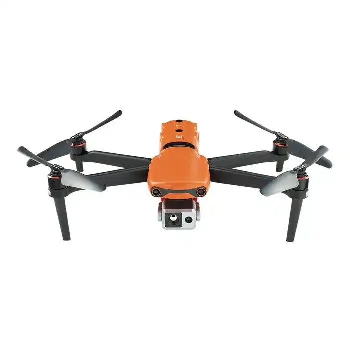
DJI Mavic 3 Thermal

REQUEST INFO/PRICE
Maximum flight time: 45 minutes.
Maximum transmission distance: 9.3 miles
Top speed: 47 mph
Maximum wind resistance: 39 ft/s.
Waterproof rating: no rating
Visual Sensor Size: 1/2″ CMOS, 4K
Infrared resolution: 640 x 512 pixels
Infrared Frame Rate: 30Hz
Thermal imaging camera: uncooled VOx microbolometer.
Infrared wavelength: 8-14 microns
DJI Matrice 350 RTK

REQUEST INFO/PRICE
Maximum flight time: 55 minutes.
Maximum transmission distance: 12.4 miles
Top speed: 51.4 mph
Maximum wind resistance: 39.4 ft/s.
Waterproof: IP55
Visual sensor size: 1080p
FPV camera field of view: 142°.
Frame rate: 30fps
Infrared detection system field of view: 30° (±15°)
Autel EVO II V3 640T
REQUEST INFO/PRICE
Maximum flight time: 40 minutes.
Maximum transmission distance: 9.3 miles
Top speed: 44.7 mph
Maximum wind resistance: 57.2 ft/s.
Water resistance: no data
Size of the visual sensor is 1/1.28″ (0.8″). 8K CMOS video
Infrared resolution: 640 x 512 at 25 fps.
Infrared Frame Rate: 30Hz
Infrared field of view: H33°V26°
Magnification: 1 to 16x
Teledyne FLIR SIRAS

REQUEST INFO/PRICE
Maximum flight time: 31 minutes
Maximum transmission distance: 6 miles
Top speed: 40 mph
Maximum wind resistance: 32.2 ft/s.
Waterproof: IP54
EO camera resolution: 16 MP with 20 MP card mode, 2 MP with 32x zoom
Infrared resolution: 640 x 512, radiometric (spot meter, isotherms, ROI)
Infrared Frame Rate: 60Hz
XT2 IR lens options: 9, 13, 19, 25mm
Best thermal cameras for drones
DSLRPros offers a wide range of DJI and FLIR thermal imaging optics. To top it all off, we look at camera resolution, as sharper images allow for better analysis, temperature range the camera can detect, thermal sensitivity – the smallest temperature difference the camera can detect – as well as frame rate and image alias. , calibration, connection and software compatibility.
The DJI Zenmuse H20T combines a 23x optical zoom camera, a 640 x 512 radiometric thermal sensor, and a laser rangefinder in one stabilized payload. The H20T also features new camera modes that facilitate more efficient data collection. These include AI Spot Check, High-Resolution Grid Photography, Pinpoint, Smart Track and Spot Metering.
The FLIR Vue TZ20-R has the unique ability to achieve thermal zoom effects by combining two separate thermal lenses and radiometric sensors, providing 1x, 5x, 10x and 20x magnification.
The Zenmuse XT2 R is a good choice because it has dual imaging and thermal imaging capabilities, as well as smart features like temperature alerts, heat tracking, and FLIR MSX technology. New to the world of infrared drones? Join the DSLPros webinar “Fundamentals of Aerial Thermography for Public Safety” here.Here’s a look at what you can expect from leading drone thermal cameras.
Understanding Thermal Drones: The Infrared Visionaries
1. Technology Disclosure:
Thermal imaging drones equipped with specialized cameras record images using infrared radiation instead of visible light. This allows them to detect temperature changes in the objects and environments they examine.
2. This is how thermal imaging works:
The thermal cameras on these drones capture infrared radiation emitted by objects. Warmer objects appear as lighter spots, while cooler areas appear darker. This technology provides valuable information for various applications.
3. Dive into applications:
Search and save:
Thermal imaging drones help locate missing people or disaster survivors by detecting body heat even in difficult terrain or poor visibility.
Environmental monitoring:
Environmentalists use thermal drones to monitor wildlife, detect wildfires, and assess the health of ecosystems by detecting temperature anomalies.
Infrastructure inspection:
Engineers and inspectors use thermal drones to identify faulty components, detect heat leaks, and assess the integrity of structures such as power lines and pipelines.
Precision agriculture:
Farmers optimize crop yields by detecting changes in plant health and humidity levels, enabling targeted and efficient use of pesticides and irrigation.
4. Advantages of Thermal Drones:
Improved vision:
Thermal imaging drones open a new perspective by revealing details invisible to the naked eye, especially at night or in adverse weather conditions.
Efficiency and profitability:
These drones enable faster inspections of large areas and reduce the time and cost of manual inspections and surveys.
Security:
Thermal imaging drones are invaluable in hazardous environments, protecting personnel from harm while providing critical data.
5. Future Innovations:
The future of thermal imaging drones looks bright with advances in the integration of artificial intelligence for real-time analysis, higher resolution thermal imaging cameras, and the integration of other sensor technologies for more comprehensive data collection.
No limits: using thermal drone technology
The emergence of thermal drones represents a revolutionary advancement in the capabilities of aerial technology: with every flight, they reveal a world beyond sight, making them indispensable tools across a wide range of industries. As technology advances, we can expect even more complex applications and a wider range of industries to benefit from the infrared vision of these drones. So let’s take flight and continue to explore the endless possibilities that thermal drones offer.
Games
Optimizing Your Gaming Experience with Uggcontroman Controller Special Settings

In the realm of gaming, where split-second decisions can mean the difference between victory and defeat, having the right controller settings is paramount. Whether you’re navigating treacherous landscapes, engaging in intense firefights, or racing against the clock, controller special settings can make or break your gaming experience. In this article, we’ll delve into the world of controller special settings uggcontroman and explore how optimizing special settings can elevate your gameplay to new heights.
Understanding Uggcontroman Controllers
Uggcontroman controllers are renowned for their precision, responsiveness, and ergonomic design. Equipped with a myriad of features and functionalities, these controllers offer unparalleled customization options, allowing gamers to fine-tune their settings according to their preferences.
The Significance of Special Settings
Special settings play a crucial role in enhancing the gaming experience. By adjusting parameters such as sensitivity, dead zones, and button mapping, players can tailor their controllers to suit their unique playstyle, resulting in improved accuracy, control, and overall performance.
Exploring Advanced Features
Uggcontroman controllers boast an array of advanced settings, empowering users to delve deep into customization options. From adjusting trigger sensitivity to fine-tuning thumbstick responsiveness, these advanced features offer endless possibilities for optimizing gameplay.
Optimizing Controller Settings for Gaming
To maximize performance, it’s essential to optimize controller settings according to your preferences and playstyle. Experiment with different configurations, adjusting sensitivity levels, dead zones, and button layouts until you find the perfect balance that suits your needs.
Improving Gameplay with Special Settings
The impact of optimized settings on gameplay cannot be overstated. Whether you’re gaining the upper hand in intense firefights or executing precise maneuvers with ease, customized controller settings can significantly enhance your gaming experience.
Common Challenges and Solutions
Despite their benefits, optimizing controller settings can sometimes pose challenges. From compatibility issues to technical glitches, gamers may encounter obstacles along the way. However, with patience and perseverance, these challenges can be overcome through troubleshooting and seeking assistance from online communities.
Community Recommendations and Best Practices
Drawing insights from gaming communities and forums can provide invaluable guidance when fine-tuning controller settings. By sharing experiences and exchanging tips, gamers can discover new techniques and recommended settings for popular games.
Ensuring Compatibility
It’s essential to ensure compatibility when optimizing controller settings for different gaming platforms. Whether you’re gaming on a console or PC, adjusting settings to suit your specific setup is key to achieving optimal performance.
Staying Updated with Firmware Updates
Regular firmware updates are essential for maintaining peak performance and compatibility with the latest games. Be sure to stay vigilant and install updates promptly to ensure your controller is always up to date.
Understanding Controller Calibration
Controller calibration plays a crucial role in ensuring accurate input recognition and responsiveness. By calibrating your controller regularly, you can minimize input lag and ensure smooth, precise gameplay.
Customizing Settings for Different Game Genres
Different game genres demand different playstyles, and customizing settings accordingly can give you a competitive edge. Whether you’re playing an FPS, RPG, racing, or sports game, adjusting settings to suit the unique requirements of each genre is essential for success.
Ergonomics and Comfort Settings
In addition to performance optimization, it’s essential to consider ergonomics and comfort during prolonged gaming sessions. Adjusting settings for comfort and accessibility can help prevent fatigue and discomfort, allowing you to game comfortably for hours on end.
Maintaining Controller Performance
To prolong the lifespan of your controller and ensure continued performance, regular maintenance is key. Be sure to clean your controller regularly and handle it with care to avoid damage and ensure longevity.
Conclusion
optimizing controller special settings is essential for maximizing your gaming experience with Uggcontroman controllers. By fine-tuning settings to suit your preferences and playstyle, you can enhance accuracy, control, and overall performance. Experiment with different configurations, seek guidance from online communities, and stay updated with firmware updates to ensure you’re always at the top of your game.
FAQs (Frequently Asked Questions)
How do I access special settings on my Uggcontroman controller?
Special settings can typically be accessed through the controller’s menu or settings interface. Refer to the controller’s user manual for detailed instructions.
Can I reset my controller settings to default?
Yes, most Uggcontroman controllers allow you to reset settings to default by navigating to the settings menu and selecting the reset option.
What are dead zones, and how do they affect gameplay?
Dead zones refer to areas of the controller’s thumbsticks where no input is registered. Adjusting dead zones can minimize stick drift and improve responsiveness during gameplay.
Are firmware updates necessary for optimal performance?
Yes, firmware updates are crucial for maintaining compatibility with the latest games and ensuring peak performance. Be sure to install updates regularly to keep your controller up to date.
How can I troubleshoot common controller issues?
If you encounter issues with your controller, try restarting your device, checking for firmware updates, and recalibrating your controller. If problems persist, contact customer support for assistance.
tech
Everything You Need to Know About “u231748506”

In today’s fast-paced digital landscape, businesses are constantly seeking innovative solutions to streamline their operations and stay ahead of the competition. One such solution that has been gaining traction in recent years is “u231748506.” But what exactly is “u’231748506,” and how can it benefit your organization?
What is “u231748506”?
“u231748506” is a revolutionary software platform designed to optimize workflow management and enhance collaboration within organizations. It offers a comprehensive suite of tools and features tailored to meet the diverse needs of modern businesses, ranging from project management to communication and beyond.
History and Development
The journey of “u231748506” began with a vision to revolutionize the way businesses operate. Its development stemmed from a deep understanding of the challenges faced by organizations in managing their workflows efficiently. Over the years, it has evolved into a robust and versatile platform, thanks to continuous innovation and feedback from users.
Key Features of “u231748506”
User Interface
One of the standout features of “u231748506” is its intuitive user interface, which makes it easy for users to navigate and utilize its functionalities effectively. Whether you’re a seasoned professional or a novice, you’ll find the platform’s interface to be user-friendly and accessible.
Functionality
From task delegation to progress tracking, “u231748506” offers a wide range of functionalities to streamline your workflow. Its seamless integration with other software solutions further enhances its functionality, allowing for a seamless experience across different platforms.
Integration
“u231748506” seamlessly integrates with popular third-party applications, such as Slack, Trello, and Google Workspace, to streamline your workflow and enhance collaboration. This integration eliminates the need to switch between multiple tools, saving time and increasing productivity.
Benefits of Using “u231748506”
The benefits of implementing “u’231748506” are manifold. Not only does it improve efficiency and productivity within your organization, but it also fosters better communication and collaboration among team members. Additionally, it provides valuable insights into your workflow, allowing for data-driven decision-making.
Applications in Various Industries
“u231748506” finds applications across a wide range of industries, from IT and marketing to healthcare and finance. Its versatility and customizable features make it suitable for organizations of all sizes and sectors, empowering them to streamline their operations and drive growth.
How “u231748506” Enhances Productivity
By centralizing your workflow management and facilitating seamless collaboration, “u231748506” enables your team to work more efficiently and effectively. Its automation features further enhance productivity by eliminating manual tasks and streamlining repetitive processes.
Case Studies
Numerous case studies demonstrate the tangible benefits of implementing “u231748506” within organizations. From startups to Fortune 500 companies, businesses across the globe have experienced significant improvements in productivity, communication, and overall efficiency after adopting the platform.
Security Measures of “u231748506”
Security is paramount in today’s digital age, and “u231748506” prioritizes the protection of your data and sensitive information. With robust encryption protocols and stringent access controls, you can trust that your data is safe and secure on the platform.
Cost Analysis: Is “u231748506” Worth It?
While the initial investment in “u231748506” may seem significant, the long-term benefits far outweigh the costs. A thorough cost analysis reveals that the platform’s efficiency gains and productivity enhancements result in substantial ROI for businesses of all sizes.
Future Trends and Innovations
As technology continues to evolve, so too does “u231748506.” The platform’s developers are constantly innovating and incorporating new features to meet the evolving needs of businesses. From AI-driven analytics to augmented reality integration, the future of “u’231748506” holds endless possibilities.
Comparative Analysis with Competitors
In a crowded market of workflow management solutions, “u231748506” stands out for its comprehensive feature set, user-friendly interface, and seamless integration capabilities. A comparative analysis with competitors highlights the unique strengths and advantages of “u231748506” in driving organizational efficiency.
Common Misconceptions about “u’231748506”
Despite its many benefits, “u’231748506” is not without its misconceptions. Common myths and misunderstandings about the platform often lead to reluctance in adopting it. By debunking these misconceptions and addressing concerns head-on, organizations can make informed decisions about implementing “u’231748506.”
Tips for Effective Implementation
Successfully implementing “u231748506” within your organization requires careful planning and execution. From conducting thorough training sessions to customizing the platform to suit your specific needs, these tips will help ensure a smooth transition and maximize the benefits of “u’231748506.”
Conclusion
“u231748506” is a powerful tool that can revolutionize the way your organization operates. By centralizing workflow management, enhancing collaboration, and driving productivity, it empowers businesses to achieve their goals more efficiently and effectively. With its intuitive interface, robust features, and commitment to innovation, “u’231748506” is poised to shape the future of work for years to come.
tech
berry0314 Shower: Revolutionizing Your Daily Routine

In the hustle and bustle of modern life, our daily routines often become mundane and repetitive. However, one aspect of our routine that shouldn’t be overlooked is the shower. Introducing berry0314 Shower – a revolutionary innovation designed to transform your daily cleansing ritual into a luxurious and rejuvenating experience.
Features of berry0314 Shower
Imagine stepping into a shower that caters to your every need with cutting-edge technology and customizable settings. berry0314 Shower offers precisely that. With its advanced features, including adjustable water pressure, temperature control, and massage functions, you can personalize your shower experience like never before. Not only does it elevate your daily routine, but it also conserves water, making it an eco-conscious choice.
How berry0314 Shower Works
At the heart of berry0314 Shower lies a sophisticated technology that combines efficiency with indulgence. Using a combination of sensors and algorithms, it intelligently regulates water flow and temperature to ensure a consistently comfortable experience. With its user-friendly interface, you can easily adjust settings to suit your preferences, making every shower a blissful retreat.
Benefits of Using berry0314 Shower
The benefits of berry0314 Shower extend far beyond mere convenience. By optimizing water usage and temperature, it promotes healthier skin and hair, reducing the risk of dryness and irritation. Moreover, its massage functions help alleviate stress and tension, promoting relaxation and overall well-being. As an added bonus, its eco-friendly design contributes to water conservation efforts while saving you money on utility bills.
Customer Reviews and Testimonials
Don’t just take our word for it – hear what our satisfied customers have to say about berry0314 Shower. From improved skin condition to heightened relaxation, their testimonials attest to the transformative power of this innovative product. Real-life experiences speak volumes, reaffirming berry0314 Shower’s status as a game-changer in the world of personal hygiene.
Comparison with Traditional Showers
In comparison to traditional showers, berry0314 Shower offers unparalleled features and benefits. While conventional showers may suffice for basic cleansing, they lack the sophistication and versatility of berry0314 Shower. Whether it’s adjusting water temperature on the fly or enjoying a spa-like massage, the difference is undeniable. With berry0314 Shower, you’re not just showering – you’re indulging in a luxurious experience.
Installation and Maintenance
Worried about the hassle of installation? Fear not – berry0314 Shower is designed with ease of installation in mind. With simple instructions and minimal hardware requirements, you can have it up and running in no time. As for maintenance, regular cleaning and upkeep are all it takes to ensure optimal performance. With proper care, your berry0314 Shower will continue to delight for years to come.
Cost Analysis
Some may balk at the initial investment required for berry0314 Shower, but rest assured, it’s a worthwhile expenditure. When you consider the long-term savings on water and energy bills, the value becomes apparent. Moreover, the priceless benefits to your health and well-being are beyond measure. With berry0314 Shower, you’re not just investing in a product – you’re investing in a lifestyle.
Conclusion
Say goodbye to mundane showers and hello to a new era of indulgence with berry0314 Shower. Revolutionize your daily routine with advanced technology, customizable settings, and eco-conscious design. Experience the difference for yourself and elevate your shower experience to new heights.
Frequently Asked Questions (FAQs)
What makes berry0314 Shower unique?
berry0314 Shower stands out for its advanced technology, customizable settings, and eco-friendly design, offering a shower experience like no other.
Is it easy to install?
Yes, berry’0314 Shower is designed for easy installation with simple instructions and minimal hardware requirements.
Can I adjust the water temperature?
Absolutely, berry’0314 Shower allows you to customize water temperature to your liking for a comfortable shower experience every time.
How does berry0314 Shower benefit the environment?
berry’0314 Shower promotes water conservation through its efficient usage and eco-friendly design, helping reduce your carbon footprint.
Are there any warranty options available?
Yes, berry’0314 Shower comes with warranty options to ensure peace of mind and customer satisfaction.

Controller Special Settings Uggcontroman: Unlocking the Potential

What’s the Max Health of Faeburrow

www health sciencesforumcom: Your Gateway to Health Knowledge

Bluefire Wilderness Lawsuit: Understanding the Case

Unlocking Academic Success with Study Island: A Comprehensive Guide

Exploring Peterlee: A Hidden Gem in County Durham

Unraveling the Complexity of Caste: Understanding Its Origins, Impact, and Modern Significance

Exploring the Sweetness of Buckwheat Honey

The Baldezinho Phenomenon: Exploring the Rise of Brazil’s Newest Cultural Craze

Vacuum Gauges: Understanding Their Importance and Types
%27%20fill-opacity%3D%27.5%27%3E%3Cellipse%20fill%3D%22%23ffffe7%22%20fill-opacity%3D%22.5%22%20rx%3D%221%22%20ry%3D%221%22%20transform%3D%22matrix(119.96767%203.25052%20-1.77656%2065.56788%20296.4%20185.5)%22%2F%3E%3Cellipse%20fill%3D%22%2300003e%22%20fill-opacity%3D%22.5%22%20rx%3D%221%22%20ry%3D%221%22%20transform%3D%22matrix(8.269%20-63.73005%20183.28345%2023.78111%20278.5%2014.9)%22%2F%3E%3Cellipse%20fill%3D%22%2300003d%22%20fill-opacity%3D%22.5%22%20rx%3D%221%22%20ry%3D%221%22%20transform%3D%22matrix(29.2198%20-54.72382%20105.01907%2056.07496%2017%20155)%22%2F%3E%3Cellipse%20fill%3D%22%239d9f89%22%20fill-opacity%3D%22.5%22%20rx%3D%221%22%20ry%3D%221%22%20transform%3D%22matrix(49.74092%2048.70991%20-22.5593%2023.0368%20164.7%20131.7)%22%2F%3E%3C%2Fg%3E%3C%2Fsvg%3E)
 Blogging Knowledge11 months ago
Workforce software eleveo

 Digital marketing8 months ago
Streamlining Financial Success: The Comprehensive Benefits of Choosing Hiveage for Invoicing
- Tech Information4 months ago
Get Ready to be Blown Away – A Review of the Geekzilla.tech Honor Magic 5 Pro
%22%20transform%3D%22translate(.8%20.8)%20scale(1.5625)%22%20fill-opacity%3D%22.5%22%3E%3Cellipse%20fill%3D%22%23fff%22%20rx%3D%221%22%20ry%3D%221%22%20transform%3D%22matrix(-208.42007%20-146.922%2023.26315%20-33.00056%20204%2012.4)%22%2F%3E%3Cellipse%20fill%3D%22%23d7d7d7%22%20cx%3D%2246%22%20cy%3D%2243%22%20rx%3D%22169%22%20ry%3D%2233%22%2F%3E%3Cellipse%20fill%3D%22%23fff%22%20rx%3D%221%22%20ry%3D%221%22%20transform%3D%22rotate(6.8%20-310.9%201988.7)%20scale(27.08468%20173.29944)%22%2F%3E%3Cpath%20fill%3D%22%23fff%22%20d%3D%22M123-16l7%2036%20130-7z%22%2F%3E%3C%2Fg%3E%3C%2Fsvg%3E)
 Blogging Knowledge4 months ago
Understanding TER Reviews: A Comprehensive Guide
- online earning10 months ago
Free Government iPhone(2023): How to Get & Where
%22%20transform%3D%22translate(.5%20.5)%22%20fill-opacity%3D%22.5%22%3E%3Cellipse%20fill%3D%22%23c7cee9%22%20rx%3D%221%22%20ry%3D%221%22%20transform%3D%22matrix(-103.0942%2026.2137%20-13.47071%20-52.97812%2061.5%20168.5)%22%2F%3E%3Cellipse%20fill%3D%22%233f4600%22%20cx%3D%2216%22%20cy%3D%2245%22%20rx%3D%22191%22%20ry%3D%2253%22%2F%3E%3Cellipse%20fill%3D%22%23c47a35%22%20cx%3D%22178%22%20cy%3D%22190%22%20rx%3D%2227%22%20ry%3D%22120%22%2F%3E%3Cellipse%20fill%3D%22%23d8695d%22%20rx%3D%221%22%20ry%3D%221%22%20transform%3D%22matrix(-28.6723%20-.65067%20.55819%20-24.59717%2077.3%2080.9)%22%2F%3E%3C%2Fg%3E%3C%2Fsvg%3E)
 Blogging Knowledge6 months ago
When Nature Strikes: The Unforgettable Day Bird Just Shat On My Sisters Face
- Digital marketing10 months ago
Best Digital Marketing Agency Primelis

 tech10 months ago
Top High DA Profile Creation Sites List 2023